



Home Power Presentation I
- Details
- Hits: 426
KM4WQC presented an introduction to home power systems. Before we can deploy or assist others we must be sure the home front is protected first; power being at the heart of the needs of your family.
Here is the audio of the presentation along with a link to an associated slideshow.
The Net Presentation Audio:
Colombian Earthquake 2026
- Details
- Hits: 1868
Colombia’s communications infrastructure experienced significant after the magnitude 7.4 earthquake on August 10, 2026. Effects were concentrated in western departments—especially Chocó, Valle del Cauca, Risaralda, Quindío, and Caldas—with intermittent service nationwide initially due to congestion.
Only a few days later things are returning to normal as far as infrastructure is concerned. The power grid is coming back online and communications systems are mostly restored.
Main Disruptions
Network congestion: A sudden surge of calls and data traffic from people checking on family/friends and contacting emergency services overloaded the communications network.
Operation Talladega Signal
- Details
- Hits: 0
As many of you may know, we have an upcoming exercise, where we'll put various amateur radio skills together to test our ability to assist in emergency response. Operation Talladega Signal will take place on March 28, 2026 at the Big Oak Hunt Camp, Talladega National Forest, 11:00AM Eastern, 10:00AM Central. This will be a great opportunity for all of us to practice our existing skills and learn new ones, so I hope you'll attend.
At the heart of the exercise will be to cooperatively use Radio Direction Finding (RDF) skills to locate a lost hiker who will be calling for help on an FRS radio. FRS frequencies are close enough to our 70cm band that our equipment should work fine, as almost all 70cm radios will tune out-of-band for receive.
Indonesian Earthquake - Amateur Radio & Digital To The Rescue
- Details
- Hits: 1501
A powerful magnitude 7.7 earthquake struck off Flores Island in Indonesia's East Nusa Tenggara (NTT) province on August 15, 2026, damaging nearly 12,000 homes, hundreds of schools and health facilities, blocking critical highway supply routes like the Trans Ende-Bajawa road via landslides, and disrupting communications throughout the region.
Indonesia's Emergency Management and Amateur Radio leadership's advanced preparation paid off. Repeaters with backup power systems and the IO-86 (Oscar 86) Satellite enhanced their HF capabilities, heavily leveraging digital modes.
Read more: Indonesian Earthquake - Amateur Radio & Digital To The Rescue
Antenna Orientation & EMCOMM
- Details
- Hits: 634
I've generally gravitated towards dipole antennas for HF, not paying a lot of attention to Verticals. While I do believe dipoles are generally more flexible, in that they can be used to communicate across a range of distances from local to world-wide, there are some advantages to deploying Verticals, especially if you're deploying with a vehicle or trailer equipped with one (or more).
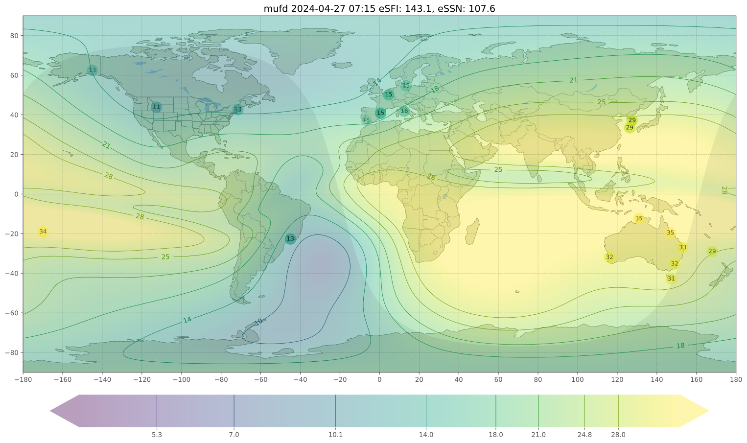
I've covered Near Incidence Vertical Skywave (NVIS) antennas before, basically deploying a dipole close to the ground. The advantage of the NVIS dipole is the ability to create a local or regional cone around the transmitting stations in the 200-400 mile range. Flying the dipole low causes radio signals to radiate more vertically, and are reflected downward rather than over the horizon. Think a water hose pointed at the ceiling of a room - the water will bounce off and scatter all over that room. Take that same dipole and raise it high (at least 1/4 wavelength above the ground) and you can now communicate world-wide.
Field Deployment Of Antennas
- Details
- Hits: 2640
Field Day provides great practice setting up antennas "on the fly" somewhere other than on home turf. However, it is a planned activity, and the event venue is often the same one, two, or few places. As a result, setting up becomes almost a reflex action in some cases. Good practice, and well worth the effort, but we often don't need to consider things like we did the first time or two we setup somewhere.
Things we have to consider when setting up at an unknown location include site selection and safety, the most efficient means of getting up and operating, propagation and proper antenna orientation, optimizing the installation, and the need to avoid some pitfalls related to setting up "on the fly".
When arriving at a new location we need to consider takeoff angles for HF and line-of-site for VHF/UHF,
P.A.C.E. and EMCOMM
- Details
- Hits: 2811
The military, various government entities, and some NGOs, plan for emergencies by implementing a multi-layered plan. Essentially, four "independent" levels, each one more reliable and less reliant on infrastructure than the one before it. As you might imagine, each letter represents one of the levels: P(rimary), A(lternate), C(ontingency), and E(mergency). I suspect you can guess which layer we fall into!
For PACE to function all players must roll through the levels in order, from P to A, A to C, and C to E. As we often say, Amateur Radio: When all else fails!
While each layer is to be independent of the resources of the preceding one, it is not always the case. Obviously, the more self-contained each system is, the more likely it is to function despite other failures.
HOAs, Amateur Radio, & EMCOMM
- Details
- Hits: 2838
Amateur Radio Operators and HOAs go together like oil and vinegar in most cases. Rules regarding antennas or "other structures" on a property bound by HOA rules often makes installation of HF antennas impossible, and even makes VHF/UHF installations challenging and less-than-optimal.
The FCC has addressed local ordinances with PRB-1, which legally inhibits local governments from imposing unreasonable limitations on radio operators. Our ability to provide emergency communications support is at the core of the argument made for PRB-1 freedoms. Sadly, PRB-1 does not impact HOAs because the HOA rules are imposed by private contract, not legal ordinances.
NVIS Antenna Configurations
- Details
- Hits: 5843
NVIS (Near Incidence Vertical Skywave) is best accomplished transmitting in the most common NVIS bands (80, 60, ad 20m) with a very high angle of incidence, the radio waves going almost straight up. This is the exact opposite of what we are doing when we're "DXing" (distant communications); as a result, almost all the logic we apply to setting up antennas is turned on its head. We must utilized antennas in ways we typically would avoid, and we'll cover the different ways here. The key is to remember we are attempting to direct radio waves upwards, rather than towards the horizon.
Dipole Antennas
These are the most common antennas in amateur radio. They are easy to make and work well. For DX, all you need to do is get them as high off the ground as you can get so the bulk of the radio signals are radiated towards the horizon.
QRP, NVIS, and 60 meters in EMCOMM
- Details
- Hits: 4267
Low Power (QRP), Near Incidence Vertical Skywave (NVIS), and the 60 meter band looks more and more to be intended for use in Emergency Communications (EMCOMM). I've touched on all of this over the last few presentations, so all I'm really doing here is putting it together.
The recent changes to the 60 meter band embrace the use of QRP on that band. What was the third channelized frequency in the 60 meter band has been eliminated, the frequency spectrum in consumed, and the adjacent portions of the band between the 2nd and 4th channels is now VFO tunable - with the caveat that operation must be QRP (9.15W ERP). The remaining channelized frequencies may still operate at the previous 100W (ERP) level.
Page 1 of 9